 Rastrac is dedicated to providing fleet managers with the best GPS tracking solutions for overcoming their day-to-day challenges. Yet, not all fleet tracking needs are the same for all fleet managers.
Some fleet managers need greater control over field operations, others need a system for improving vehicle maintenance, some just need a strong antitheft system. This is why Rastrac has spent years developing different GPS tracking solutions to fit a variety of needs.
One particularly useful tool that Rastrac has developed for fleet managers is StreetComplete. Here are a few reasons that you might want to augment your GPS tracking solution with Rastrac’s StreetComplete plugin:
1: You Have Strict Schedule Adherence Requirements
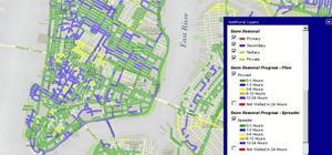
Municipalities frequently use StreetComplete because it can make managing tasks that require frequent repeating easier to manage. The plugin’s customizable color coding system allows users to have an “at a glance” view of how much time has passed since a particular route received service.
For example, in winter, municipalities often use StreetComplete to manage snowplow operations. Here, custom timers can be set according to the city’s needs, and fleet managers can see which roads are the most in need of clearing.
Police can use the plugin to enhance patrol dispatch, creating color-coded maps that show how long it has been since a patrol vehicle has visited a particular street.
Knowing how long it has been since a given route was visited is a powerful tool for improving coverage in a given service area.
2: You Need “At a Glance” Monitoring for a Given Service Area
Because you’re able to customize the time ranges assigned to each color, StreetComplete is a very powerful and versatile tool for performing live monitoring of a given service area at a glance.
For example, you could set a green color code for a service route that was just visited, a yellow one for a route that is nearing your normal deadline for the next service, and a red code for a route that is overdue for service.
This allows you to quickly assess which routes are most in need of service with a glance at your monitor.
3: To Optimize Field Asset Allocation
While normal GPS tracking solutions can help massively improve the distribution of your assets in the field, using StreetComplete can help you take this a step further.
Knowing which areas are most in need of service allows you to redistribute your field assets to where they can have the biggest impact without excessive overlapping; which helps improve the overall efficiency of your field operations.
In short, StreetComplete is ideal for any fleet manager that has a defined service area that requires frequent service.
Learn more about StreetComplete today!

Like what you're reading? Subscribe to our blog.
Get our latest posts straight to your inbox.
Subscribe to Our Blog